

Beled Weyne, Somalia has been impacted by yet another major flood in the past few weeks. More than 200,000 residents have been impacted, some loss of life has been reported and the total devastation of this catastrophic event is yet to be determined. Beled Weyne city is the most populous city in Hirshabelle state with a population of 400,000 residents based on some estimates. These floods have inundated majority of the city by some estimates more than 80 percent of the city is under flood waters. Aid agencies, Somali citizens and the Federal government have all pledged support and mobilized to respond to this event.
How did we get here?
Flooding is a natural event and although one can plan and try to mitigate the impacts of a flood event, the risk from flooding can never be eliminated. Nevertheless, one must wonder why this cycle of draught and flooding continues to ravage Somalia. Beled Weyne has always been impacted by floods dating back to colonial era and recently in 1997, 2006, 2018 and 2019.
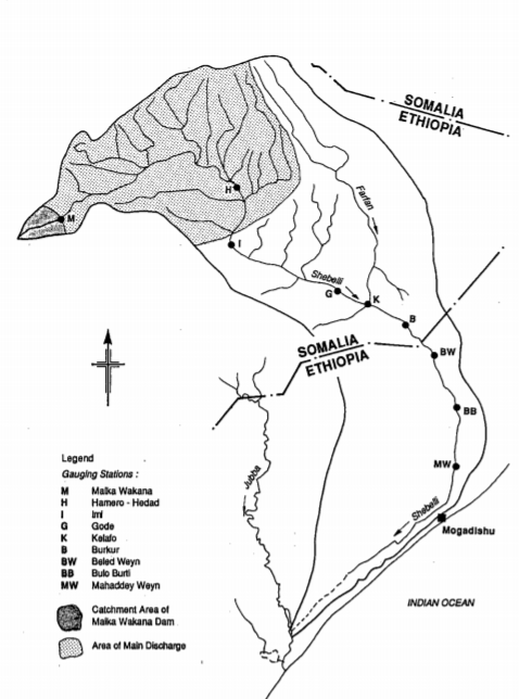
Beled Weyne is located along the Shabelle river and it is the most upstream city within the Somali national boundary. The seasonal weather variations for Beled Weyne and southern Somalia in general are influenced by the northward and southward movement of the Intertropical Convergence Zone (ITCZ). The ITCZ moves northwards in the first half of the year and southwards in the second half of the year. This movement of the ITCZ is the main cause of the seasonal weather patterns in southern Somalia. There are four seasons in Somalia; Jilaal, Gu, Xagga and Dayr. The main rainy season in Somalia is the Gu season, which is between April and June. The intertropical front enters southern Somalia around March moving northeasterly and the Gu season occurs behind the intertropical front between April and June. The second rainy season is Dayr and runs from October to November. Although, continuous rainfall was recorded within the Shabelle basin section in Somalia, the bulk of the river flow originates from the highlands of Ethiopia.

Shabelle River Basin showing the location of Beled Weyne
More than normal Dayr rainfall in Hiraan region and the highlands of Ethiopian upstream resulted in an increase in water levels in the Shabelle river. Small ephemeral channels within the Somali portion of the catchment all contributed during this period and weather stations maintained by FAO reported increase in the river levels early October. As early as August, FAO indicated that models were showing a higher probability for a wetter Dayr. Warnings were issued by the various aid agencies as the river level continued to increase. Degraded river banks, non-engineered levee systems and developments adjacent to the river increased the risk the flood impacts.

Location Map of Beled Weyne showing how the river encircles the city
This is nothing new
This is not the first time the residents of Beled Weyne had to flee the town due to flooding. Dating back to the colonial era, residents reported flooding and had to relocate to higher ground. Some of the earliest recorded flooding occurred after independence in 1961 along the Shabelle and Juba rivers. Then there was 1981 Gu floods that impacted the Shabelle basin and resulted in wide spread displacement of the residents in Hiraan region. The most devastating flood to impact Beled Weyne was the El Nino event of 1997/1998 that led to widespread flooding and loss of life in Beled Weyne and other communities along the Shabelle and Juba rivers. The 1997/1998 El Nino was a unique event where the entire catchment for the Shabelle river received record rainfall and all ephemeral streams in Somalia contributed to the river flooding. By some estimates close to one million citizens where impacted by the flood which occurred post the civil war era with no functioning central government. Ever since the 1997 El Nino flood, the frequency and severity of the flooding seemed to increase. Major floods ravaged Beled Weyne in 2006 during the Dayr season (similar to this flood). The 2006 flood also displaced majority of the residents in Beled Weyne and inundated close to 80% of the city. The most recent floods occurred last year during the Gu season. The April 2018 floods impacted majority of the city and occurred just months after Hiraan was suffering from drought conditions.
So what is causing this reoccurring flooding phenomena?
Hard to say, but most likely a combination of factors including some of the following:
- Impacts of the 1997/1998 El Nino on the existing flood control infrastructure – With the collapse of the central government in 1991, no rehabilitation initiatives occurred in Somalia to clear the excessive sediment and debris in the river or maintaining the existing infrastructure. The 1997 El Nino overwhelmed the existing facilities and at many locations breached the levees and created severe damages throughout. Some of these breakages have been rehabilitated by aid agencies since 1997 but it is unknown if all breakages where rehabbed. Overflow channels created during the colonial era and by the Somali government were buried or collapsed during the El Nino event. These overflow channels were vital in diverting river flow during flood periods.
- Climate change – whether you believe in climate change or not, it is hard to argue with the temperature changes in both sea level and land. Small increases in temperature can impact the weather patterns and how storms form. Perfect examples are the recent tropical and cyclonic storms in Somaliland (tropical storm SAGAR) and Puntland/Somaliland (tropical storm KYARR just last week).
- Development and settlement’s on the floodplain – uncontrolled settlements on the river flood plain increased the risk of flooding to the residents. The river meanders and encircles the city which makes it difficult as is, leaving the adjacent area to the river clear and open during high flow events is critical.
- Sediment and debris pile up in the river – close to 30 years of minimal maintenance will reduce the capacity of the river and result in overflow of the banks from smaller storms.
Where do we go from here?
Somalia has been relying on aid agencies to provide funding and assistance on essentially every disaster related task. From the 1960’s, aid agencies played an imported role in developing the hydrometric network for Juba and Shabelle rivers. This included various studies including, land survey, soil survey, and establishing the monitoring stations. While we should be grateful to the international community for providing this assistance, one must wonder at what point will the locals and the government take ownership of this issue and try to gain a deeper understanding of why they keep reoccurring. Most of the watershed for the Shabelle river (same as Juba) lies within Ethiopia, and Ethiopia maintains a network of gauges along the rivers. A list of gauges upstream of Beled Weyne is shown in the figure below.
Why hasn’t the Federal Government coordinated with the Ethiopian counter-parts to establish a transboundary monitoring system for the river?

Wabi Shabelle Survey by the Ethiopian Government 1973
The figure above (circa 1973) illustrates the profile of the river within Ethiopia. The dark black rectangles represent the hydrometric network maintain by Ethiopia upstream. The Ethiopian National Meteorology Agency maintains a robust amount of data, see the link below.
It is crucial for the Somali Federal government to coordinate with their Ethiopian counter parts to share data. For example, the Ethiopian government has weather gauging station in Kelafo to monitor the rainfall and the river levels. Kelafo is upstream of the Somali national border and the water levels in Kelafo and Mustahil would be vital for Beled Weyne.
Hydrometric Project By Government of Somalia 1991
Within Somalia, all the active hydrometric network and weather stations along with all the pertaining data are in the hands of aid agencies. The Somali government completed a detailed hydrometric inventory and field verification in 1991 by Sir M MacDonald & Partners Limited. FAO/SWALIM maintains 120 weather stations and 8 stream gauges along the rivers. It is crucial for the Somali government to develop this capability. If the problems are not understood from a macro or a system level, long term solutions will not be developed to solve these redundant issues. Currently, Somalia relies on aid agencies to identify the problems and to also come up with solutions.
Somalia needs a national improvement plan to tackle Disaster Response and Planning
To alleviate this issue, the Somali officials need to develop a strategic plan to look at the reoccurring disasters from inception instead of always responding spontaneously to each event. To accomplish this there are some short-term needs and long-term needs, some examples are shown below.
Short term:
- Develop a disaster response plan – The number one priority right now is to develop a disaster and emergency response plan before disaster ever occur. This requires a lot of planning and coordination between Federal and Hirshabelle officials. Since you know the risk to flooding is always there, planning will not only save lives but also reduce the overall cost to address the damages. Somalis are very generous only when they see the disaster and impacts but not with planning, we need to change that paradigm.
- Set up a transboundary agreement with Ethiopia – A transboundary agreement with Ethiopia is needed for Juba and Shabelle rivers. Most of the contributing watersheds to both Juba and Shabelle are located within Ethiopia, this where almost all of the water (90% by some estimates) in the river comes from, when they have flooding in certain parts of Ethiopia you can certainly expect the flood waters to reach Somalia. Having coordination with Ethiopia will potentially save lives and provide ample warning time to evacuate the areas.
- Fix the known levee and bank breakages – This is critical to reduce the damages from the next major event. The first step to addressing this issue could be using aerial imagery and remote sensing techniques but ideally, detailed elevation data would be used.
- Develop a topographic (elevation) map of the entire river floodplain – This will be costly but can be done in a short amount of time using the latest technology such as LiDAR and high resolution satellite data. Having a high-resolution elevation data will be beneficial in many ways and underline the following:
- Areas where the levees and the riverbanks have been damaged (some date back to the 1997 El Nino)
- Areas where new development has occurred or encroached into the floodplain. Based on the elevation data and the way the river meanders in the City, certain parts of the city should not be inhabited. Developing in those areas will always pose a risk to the residents.
- Developing a detailed hydrologic and hydraulic modelling to highlight the areas prone to high risk of flooding. With the currently state of technology, one can produce a detailed two-dimensional model for the entire area that depicts real physical characteristics of the area
Long term:
- Develop Expertise – The Somali government should advocate for and assign scholarships in the fields of hydrology, meteorology and water resources. Developing these expertise within the country is vital in understanding the system and creating long term solutions. You can not depend on aid agencies forever.
- Develop Systemwide studies – Develop planning studies to understand the water balance in the watershed and flood prone areas. From the planning studies you can prioritize what is the most critical areas and develop a flood control solution for each area. Ideally you should not initiate construction projects without knowing the challenges holistically.
- Develop Weather and Hydrometric Networks – This is very important to understand the potential risk and to monitor the water levels in the system and track the rainfall that is falling in the area. This step could be done immediately, since there are many companies worldwide that can assist to jump start this effort. To get it right, it is vital for the expertise to be developed locally so that you are not relaying on others to interpret the data for you.
- Flood Control Solutions – Based on the results from the planning projects and prioritizations, develop solutions to either divert the water, create engineering levees, or a major effort to remove the access sediment from the entire system. These projects should not produce any adverse impacts to downstream communities, that is why it is vital to do the systemwide planning studies first.
I get that Somalia has other priorities, mainly security now and unfortunate political gridlock, these short-term solutions could be done without a significant amount of cost. The aid money allocated for droughts and flooding response far outweigh both short term and long-term solutions listed combined. The key is to take ownership of these issues and stop relaying on others. Beled Weyne residents could do some of the items in the short term without relaying on anyone by developing their own disaster response plan locally or prohibit development in certain parts of the floodplain.


